Muirkirk Branch (Glasgow, Paisley, Kilmarnock and Ayr Railway)
Introduction
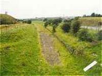
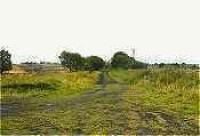
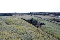
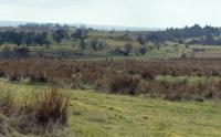
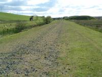
This line is closed. The line was to be re-opened from Auchinleck to Cronberry and then a section of the Gaswater branch for coal traffic from an opencast site.


Dates
| 09/08/1848 | Muirkirk Branch (Glasgow, Paisley, Kilmarnock and Ayr Railway) Auchinleck to Muirkirk [1st] opened. The line served the Lugar Iron Works, the Muirkirk Iron Works and various coalmines. |
Locations along the line
These locations are along the line.
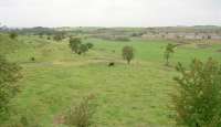
This junction was immediately east of Auchinleck station between the lines to Muirkirk and the main line from Glasgow St Enoch to Carlisle. Muirkirk Junction Shed was located in the 'v' of the junction. The Muirkirk branch singled shortly after the junction, with initially only the westbound line laid.
...
See also
Glasgow, Paisley, Kilmarnock and Ayr Railway
...
More detailsThis junction was directly east of Muirkirk Junction, Auchinleck. It was the start of two mineral lines which left the north side of the Muirkirk branch heading west before turning north - both lines running parallel for about a third of a mile before the western of the two lines continued north to Gilmilnscroft Colliery and the eastern ran north east to Common, Ballochmyle and Darnconner ...
More details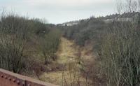
Bill Roberton //2004
Ewan Crawford 20/02/2005
Ewan Crawford 20/02/2005
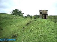
This was the junction for coal pits to the west of Birnieknowe Farm on a short branch going north from the Muirkirk line, approached from the east. To the south was a line to Blackston Colliery, also approached from the east.
...
...
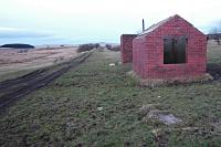
More detailsThis was a two platform station in a shallow cutting which did not open with the line. The timber ticket was elevated at street level, on the north side above the eastbound platform and there were waiting rooms on each platform. There was no goods yard.
...
Ewan Crawford 20/02/2005
This was the junction for the Common Branch, between Commondyke (to the west) and Lugar (to the east). The branch was approached from the west. It ran north to the Common pits. The branch dated from the 1850s, or earlier.
...
This was a two platform station built principally to serve the Lugar Iron Works, Lugar village, and other nearby works. There was a small private goods yard on the south side, served from the west. The main building was on the westbound platform (iron works and village side of the station).
...
Ewan Crawford 20/02/2004
This junction was east of Lugar station. The Lugar Ironworks was reached by reversal from sidings just to the east, on the south side of the line. The branch ran south west and then south to the works via Rose Junction. The reversal sidings, Cronberry Sidings Nos 1,2,3, may have originally been looped with their east end at Cronberry Pits No 1,2,3 Signal Box.
...
See also
Lugar Ironworks Railway
Cronberry Pit No 1 was an ironstone mine located to the north of the Muirkirk line near Lugar station.
...
See also
Lugar Ironworks Railway
Bill Roberton //2004
This signal box was a little west of Cronberry Junction, just west of the Mosshouse Viaduct. It controlled access to a short curving branch which ran north to Cronberry Tileworks and Cronberry Pit No 4. The pit was relatively short lived but the tile works outlived the pit and continued to be served by a siding.
...
Bill Roberton //2004
Bill Roberton //2004
Ewan Crawford //
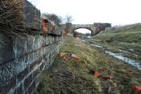
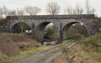
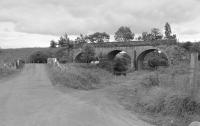
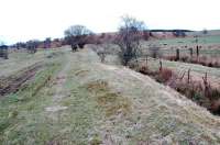
This was a three arch double track viaduct over the Bellow Water. The viaduct was rebuilt to take a double track and fell out of use in 1976.
...
...
Bill Roberton //2004
Bill Roberton 16/07/1998
...
More detailsThis junction was directly west of Cronberry station. The Auchinleck to Muirkirk [1st] line of 1848 was met by the line from Ayr via Belston Junction in 1872.
...
See also
Ayr and Cumnock Line (Glasgow and South Western Railway)
Ewan Crawford //1996
Ewan Crawford 20/02/2005
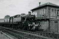
Cronberry was a two platform station to the immediate east of Cronberry Junction, a junction formed between the line from Auchinleck and the line from Belston Junction to Muirkirk [2nd]. The platforms were stone with a timber station building on the westbound platform and a signal box at the west end.
...
Roger Geach Collection 23/08/1975
...
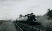
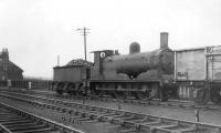
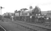
Jim Currie (Courtesy Stephenson Locomotive Society) 20/06/1962
...
Jim Currie (Courtesy Stephenson Locomotive Society) 20/06/1962
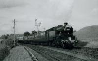
...
Jim Currie (Courtesy Stephenson Locomotive Society) 20/06/1962
...
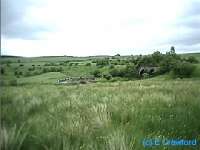
More detailsThis was the junction between the Muirkirk branch and the Gass Water branch, named for the water course running south west off the high ground to the east of the railway. The branch saw a variety of uses over its lifetime; limestone, coal and baryte being extracted. The location was at Carbellow Farm. The spelling of the name 'Gass Water' has varied. The water course is the Gass Water but the ...
More details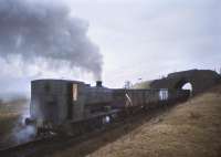
Bill Roberton //1974
Ewan Crawford 20/02/2005
Bill Roberton //1974
A loading pad, and preparation plant, for the Gasswater Baryite Mine which was to east and connected by an aerial ropeway. The mine had its own narrow gauge railway system. The ropeway replaced the western part of this railway.
...
...
More detailsArray
More details...
More detailsThis signal box, opened 1881 (the line was doubled in 1883), was north east of Cronberry Crossing and controlled the siding for Carbellow Ironstone Pit No 3, to the south west.
...
This was the junction for the short branch south east to Welltrees Mine No 3 and Welltrees Mine No 4. Access was from the west. Both main line and branch crossed the Welltrees Burn at this point by separate, but very close together, parallel bridges.
...
...
More detailsWelltrees was on the east side of the Welltrees Burn. It was served by a short branch from Welltrees Siding on the Muirkirk line which ran south beside the east bank of the Welltrees burn.
...
...
More details...
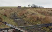
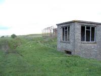
More detailsThis was a 1950s set of sidings with an entry control cabin, shed/workshop, exchange sidings and main sidings. The site was on an east-west orientation with a connection to the GSW Muirkirk which faced west, the sidings being on the south side and parallel to that line. A building straddled at least one line in the sidings at the east end of the site.
...
Ewan Crawford 26/05/2003
Ewan Crawford 26/05/2003
Ewan Crawford 26/05/2003
Welltrees was on the east side of the Welltrees Burn. It was served by a short branch from Welltrees Siding on the Muirkirk line which ran south beside the east bank of the Welltrees burn.
...
This signal box controlled a siding on the south side of the line, served from the west. The siding formerly served Wellwood Pit by reversal. This pit was to the south and on higher ground.
...
This pit was to the south of the Muirkirk Branch (Glasgow and South Western Railway). Access to the pit was by reversal from a siding controlled by Wellwood Siding Signal Box.
...
This signal box was west of Muirkirk [1st] and controlled access to the short branch to Wellwood No 1 Pit, a coal pit.
...
...
More details...
More detailsThis signal box was west of Muirkirk [1st] station. It controlled the western approach to the station, goods yard and Muirkirk Shed. It also controlled access to the private line running from the station round the north side of the box to Kames Colliery and on to pits at Wellwood. The box was west of the station and on the north side of the main line.
...
This was a two platform station, dating from 1848, opened by the Glasgow and South Western Railway. It was originally a terminus, although the line continued east through the station to the Muirkirk Ironworks, just to the north. The line to the works was initially double, later reduced to single. Another branch continued east, through what would later be the second station, and then south ...
More details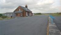
Ewan Crawford //1996
David Stewart 20/04/1962
Ewan Crawford 25/05/2003
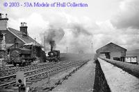
Models of Hull Collection / John Turner //
The Muirkirk Ironworks were located south of present day Muirkirk. They were established in what was a remote area by John Robertson, John Gillies, and Thomas Edington.
...
See also
Baird^s Railway (Muirkirk)
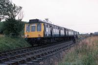
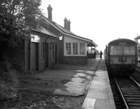
This was a two platform station dating from 1896. This is the better known station at Muirkirk which was in use as the lines closed.
...
See also
Muirkirk Branch (Caledonian Railway)
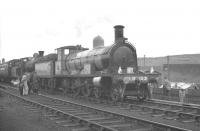
Ewan Crawford //1999
K A Gray 30/06/1963
K A Gray 30/06/1963
Colin Miller /10/1964
Muirkirk East signal box was to the east of Muirkirk [1st] station and on the south side of the line opposite the junction for the Muirkirk Iron Works. It was on the eas side of Furnace Road.
...
