Wellwood Opencast Disposal Centre Sidings

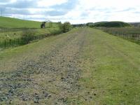
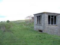
Two miles east of Cronberry, Gass Water Junction and Cairnhill Colliery is this much lesser known location. This is the view looking east from a shed or workshop at the west end of the site. To the left is the Muirkirk branch and ahead were exchange sidings and beyond that the loading point. A signalbox was provided and the stumps of signal posts remain.
The site was probably associated with the failed NCB developments at Mortonmuir (never opened due to water problems; sunk 1947 closed 1953) and Powharnal (sunk 1954 closed 1959).
The site can be seen on 1950s OS maps and was probably already closed when the line closed between Cronberry and Muirkirk in 1969.
The location can be found the British Transport Commission's 'Official Hand-Book of Stations (1956)' as Scottish Division, No 8. (East Ayr) Area, Wellwood Opencast Disposal Centre.
The location would have been useful, had it remained, as the Powharnal opencast was to open just to the south over the A70, later extended to the site of the Wellwood and Nether Wellwood mines.
(See query 1361 and many thanks to all who responded.)
Location: Wellwood Opencast Disposal Centre Sidings (former)
Original line: Muirkirk Branch (Glasgow and South Western Railway)
Photographer: Ewan Crawford
Contact photographer: Ewan Crawford
Date: 26/05/2003
Image number: 53759
Other photographs of Wellwood Opencast Disposal Centre Sidings on RailScot
 |  |
