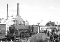
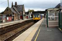
Burscough Bridge

A map extract showing the position of the railways, two stations and also the canals around Burscough in 1907. The Leeds Liverpool Canal runs mid left to bottom right with the Rufford Branch going north to eventually reach the sea lock at Tarleton. The Liverpool to Preston line and that from Southport to Wigan are connected by the two now disused forks. There are recurring proposals to reinstate these curves and provide an interchange between trains from Preston, Southport, Wigan and an extended Merseyrail Electrics service at Burscough Bridge. The south fork 22975 was used until the early 1980s to access the MOD Ordnance Stores. I remember the trains calling there, and also seeing Green Goddess fire engines stored in the compound, but it is now covered by housing. Map uploaded by Mark Bartlett with the permission of the National Library of Scotland http://maps.nls.uk/index.html
Location: Burscough Bridge
Original line: Southport Branch (Lancashire and Yorkshire Railway and East Lancashire Railway Joint)
Photographer: National Library of Scotland
Contact photographer: National Library of Scotland
Date: 1907
Image number: 78118
Other photographs of Burscough Bridge on RailScot
 |  |  |  |  |  |  |  |  |  |
