Cogie Hill

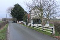
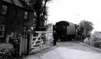
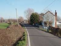
A 2020 view looking west towards Pilling at the site of Cogie Hill Crossing and Halt, together with an extract from the 1912 25inch OS Map. The line proceeded across this field from the crossing towards the gate on the far side. The halt was on the south side of the track between the line and Island Lane. There is no trace of anything in the field now, including the former peat moss litter works with its siding. Shown as closed in 1912 it reopened in 1915 and continued in production until 1931. The crossing keeper's cottage, on the east side of the crossing, is still in residential use. See image 72129. Map extract reproduced with permission of the National Library of Scotland.
Location: Cogie Hill (former)
Original line: Garstang and Knot End Railway
Photographer: Mark Bartlett
Contact photographer: Mark Bartlett
Date: 10/08/2020
Image number: 73952
Other photographs of Cogie Hill on RailScot
 |  |  |  |  |
