Machrihanish Farm

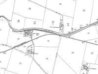
Extract from an 1899 Ordnance Survey map showing Argyll Colliery before the line through to Machrihanish village was built. The light railway for coal traffic runs eastwards from the colliery. Machrihanish Farm Halt would later be sited by the river bridge at West Machrihanish and then the railway turned south west to bisect the track between Trodigal and the mine on its way to the Machrihanish terminus. See image 67675 for the same area on a 1921 map extract with the full C&MLR in operation.
Location: Machrihanish Farm (former)
Original line: Campbeltown and Machrihanish Light Railway
Photographer: Mark Bartlett
Contact photographer: Mark Bartlett
Date: 1899
Image number: 67690
Other photographs of Machrihanish Farm on RailScot
 |
