Machrihanish Farm

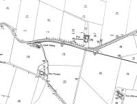
Extract from 1921 map showing the Argyll Colliery and the line of the Campbeltown & Machrihanish Railway that was built to serve it but later extended to Machrihanish for passengers. Machrihanish Farm Halt is marked on the map but Trodigal Halt, which was where the line crossed the main road, is not shown. The original colliery closed in 1929 leading to the demise of the line a few years later. A new colliery was sunk in 1950 See image 61673 but this was sited nearer the road.
Location: Machrihanish Farm (former)
Original line: Campbeltown and Machrihanish Light Railway
Photographer: Mark Bartlett
Contact photographer: Mark Bartlett
Date: 1921
Image number: 67675
Other photographs of Machrihanish Farm on RailScot
 |
