Pitmuxton Siding

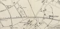
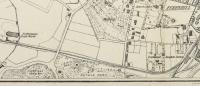
This shot shows the approximate location of what was called Pitmuxton Siding; this lay between what is now Gairn Terrace to the north, shown here, and Allanvale to the south. The location is shown on a 1883 Post Office Directory map of Aberdeen and can be deduced from the 1902 Ordnance Survey 25' map. It had been built to serve the Ruthrieston Brickworks (1868-1883) north of the railway on the estate called Pitmuxton. This name has almost totally disappeared from the City since Pitmuxton House was renamed Pitstruan House around 1860.
Location: Pitmuxton Siding (former)
Original line: Deeside Railway
Photographer: Charlie Niven
Contact photographer: Charlie Niven
Date: 17/11/2018
Image number: 66686
Other photographs of Pitmuxton Siding on RailScot
 |  |
