Edinburgh cyclists launch interactive 'Innertube' map [BBC]
Date: 25/02/2011
A map detailing Edinburgh's extensive cycle path network has been developed by local enthusiasts. A team from the bicycle recycling charity the Bike Station have launched the 'Innertube', taking inspiration from London's underground map.
External links
'Tube' map for Edinburgh cyclists
BBC
A interactive map detailing Edinburgh's cycle path network is developed by local enthusiasts.
Related images
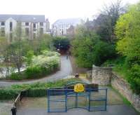
A young woman with a pushchair walks from King George V Park, through the site of Scotland Street station towards the south portal of the newly reopened Rodney Street Tunnel, perhaps on her way to visit the superstore located alongside the northern approach. The old tunnel now provides a useful pedestrian and cycle link between this part of the New Town and the Broughton area, avoiding the need to cross two very busy roads. [See image 36593]
Location: Scotland Street
Company: Edinburgh, Leith and Newhaven Railway
14/04/2009 Andy Furnevel
Location: Scotland Street
Company: Edinburgh, Leith and Newhaven Railway
14/04/2009 Andy Furnevel
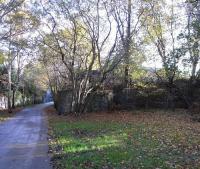
The NBR North Leith Branch, now a walkway, looking towards the terminus on 31 October 2009. A little behind me was Bonnington station, still substantially intact. Through the fence to the right ran the goods lines serving the once industrial Bonnington area, split in two by the Water of Leith which the lines crossed. There was a goods station at the start of the branch, then lines fanned out into a dense pattern serving tanneries, ironworks and the like. At one point a line formed a tight figure 4; presumably worth all the required reversing in a pre-motor age.
Location: Bonnington Goods Junction
Company: Edinburgh, Leith and Granton Railway
31/10/2009 David Panton
Location: Bonnington Goods Junction
Company: Edinburgh, Leith and Granton Railway
31/10/2009 David Panton


