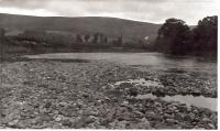
Cambus o' May

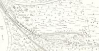
The siding shown on this Ordnance Survey map from 1865 to be leading away from the running line to an area of excavation on the hillside a few hundred yards away was extending into a ballast pit. Added by Charlie Niven. With permission of the National Library of Scotland. maps.nls.uk/copyright.html
Location: Cambus o' May (former)
Original line: Aboyne and Braemar Railway
Photographer: National Library of Scotland
Contact photographer: National Library of Scotland
Date: 1865
Image number: 73053
Other photographs of Cambus o^ May on RailScot
 |  |  |  |  |  |  |  |  |  |
