South Gyle

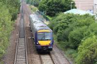
A Fife Circle DMU passes the site of the Gyle Centre. In the foreground is a trial embankment. The purpose of this was to measure the amount and timing of settlement of the underlying peat layer. This area was to form car parking and to achieve a stable base it was decided to consolidate this compressible stratum using red blaes embankments built up in layers (surcharging). In order to determine the amount of time to achieve stability a trial area was built and magnetic extensometers were installed to monitor the downward movement. A measuring tape reel is shown; this had a probe at the end containing 3 Reed switches and was used to detect magnets at intervals along the black plastic pipes shown. These were installed vertically in boreholes and extended upwards as the blaes was added. This system can also be used to measure (unwanted) settlement in railway embankments.
Location: South Gyle
Original line: Forth Bridge Connecting Lines (North British Railway)
Photographer: Charlie Niven
Contact photographer: Charlie Niven
Date: 12/1991
Image number: 63698
Other photographs of South Gyle on RailScot
 |  |  |  |  |  |  |  |  |  |
