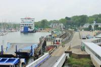
Lymington Pier

An extract from a pre WWI OS 6 inch map showing the railway layout at Lymington. Comparison with the present day shows little difference although a marina has been constructed on the mud flats opposite the Pier station and a large car park at the Pier itself. See image 47483. Added by Mark Bartlett. Reproduced with the permission of the National Library of Scotland http://maps.nls.uk/index.html
Location: Lymington Pier
Original line: London and South Western Railway
Photographer: National Library of Scotland
Contact photographer: National Library of Scotland
Date: 1913
Image number: 58483
Other photographs of Lymington Pier on RailScot
 |  |  |  |  |  |  |  |  |  |
