Scotland

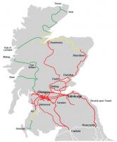
The bottom right-hand corner of the BR Scottish Region network map for 1960-61 showing the diagram of lines in Edinburgh - when such a thing was still needed. I am intrigued by the placing of the regional boundary on the map - correctly placed on the border at Gretna Junction, but why is Longtown, Cumberland, apparently part of Scottish Region? It had maroon London Midland Region signage. Maybe it was a cartographer's error?
Location: Scotland
Original line: Maps
Photographer: David Panton
Contact photographer: David Panton
Date: 1960
Image number: 26310
Tags: MapOther photographs of Scotland on RailScot
 |  |  |
