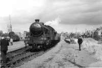
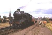
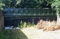
Dalkeith

The Dalkeith area as seen on the 1957 OS One Inch map. The Waverley
Route runs north to south and is the source of various branches
including the short one to Dalkeith itself (the white rectangle) which closed during WWII. Notice also below Eskbank the stub of the line which once extended to the Dalkeith Colliery line, then existing as far as Thornybank (as it's now spelled). To the east there was once a halt at Crossgatehall on the Ormiston line. Crown copyright 1957.
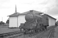
Location: Dalkeith
Original line: Maps
Photographer: David Panton
Contact photographer: David Panton
Date: 1957
Image number: 33531
Tags: MapOther photographs of Dalkeith on RailScot
 |  |  |  |  |  |  |  |  |  |
