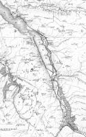
Map

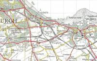
Maps at a scale of four miles to the inch are normally of limited use to PLU (People Like Us) but this Ordnance Survey edition of 1921 does have the advantage of showing railway stations prominently. Here, blown up somewhat, it shows how dense was the network of the Edinburgh Area compared with today. I count 58 stations in this extract; there are now only 13. The 58 however includes Powderhall, which I believe closed for good in 1917, and South Leith which closed in 1905. (Crown Copyright 1921)
Location: Map
Original line: Maps
Photographer: David Panton
Contact photographer: David Panton
Date: 1921
Image number: 31393
Tags: MapOther photographs of Map on RailScot
 |  |  |  |  |  |  |  |  |  |
