Weardale Extension Railway (Derwent Iron Company)
Introduction
This line is closed. A short section of it from Waskerley to Burnhill is part of the Waskerley Way footpath.


Dates
Locations along the line
These locations are along the line.
...
More details
Ewan Crawford 26/09/2006
Ewan Crawford 26/09/2006
2 of 2 images.
...
More details...
More details...
More details...
More details
Ewan Crawford 26/09/2006
1 of 1 images.
...
More details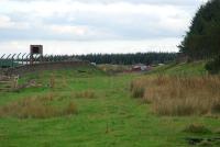
Ewan Crawford 26/09/2006
Ewan Crawford 26/09/2006
2 of 2 images.
